
Named Models
 Prithvi-EO-2.0-600M-TLIBM, NASAReleasedDec 2024Runs onnot in the notesClassgeospatial
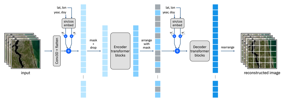 TL variant, 8% above Prithvi v1 across GEO-Bench tasks; beats six other GFMs at 0.1 to 15 m.Commercial use: allowed; Jakarta hosting: unknown; Indonesian support: not statedPrithvi-EO-2.0 600MIBM, NASAReleasedDec 2024Runs onsingle datacentre GPUClassgeospatial
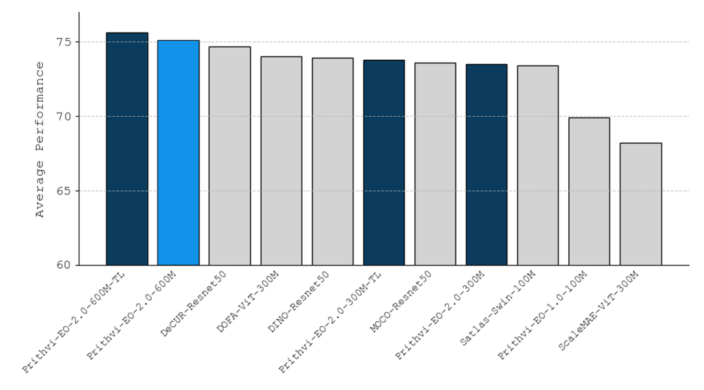 Prithvi-EO-2.0 size variant.Commercial use: allowed; Jakarta hosting: unknown; Indonesian support: not stated
Where this comes from
Models the research names for this use case. Research, with sources on each model record.
Who Runs It
research, 1
 BRIN Data Science and Information Research Center (PRSDI)Country: IndonesiaDecentralised AI framework with federated learning on optical and radar satellite imagery (NDVI, VV/VH) for rice growth stage monitoringVendor: BRINresearchDate10 Mar 2026
In development; no results statedEvidence: government statementConfidence: mediumSource: rri.co.id
Where this comes from
Documented uses by named organisations. The evidence column says who made the claim.
Candidate Models
 DINOv3 SAT-493M ViT-7BMeta, geospatialReleasedAug 2025open weightslast 18 monthsDINOv3 SAT-493M ViT-L (distilled)Meta, geospatialReleasedAug 2025open weightslast 18 monthsTerraMindIBM, European Space Agency (ESA), Julich (Forschungszentrum Julich), geospatialReleasedFeb 2025open weightsruns on edgeTerraCodecIBM, geospatialReleased2025open weightsruns on edgePrithvi-EO-2.0 TINY-TLIBM, NASA, geospatialReleasedDec 2024open weightsruns on edge
 Natural Forests of the World 2020 model (MTSViT)Google DeepMind, Google, World Resources Institute (WRI), IIASA, geospatialReleasedNov 2025last 18 months
 RingMo-AgentAerospace Information Research Institute, Chinese Academy of Sciences (AIRCAS), geospatialReleasedJul 2025last 18 months
 SkySense V2Ant Group, geospatialReleasedJul 2025last 18 monthsAlphaEarth Foundations (Satellite Embedding v1 Annual)Google DeepMind, geospatialReleasedJul 2025last 18 monthsRingMoEAerospace Information Research Institute, Chinese Academy of Sciences (AIRCAS), geospatialReleasedApr 2025last 18 months
Showing 10 of 32. All models of this class
Where this comes from
Derived, not researched: models in the directory whose class matches a class this use case uses, excluding family records and models shut down or deprecated. Ranked by how many fit facts they meet, then by release date. Each fit fact is read from the model record.
Links
Sources
- ibm-nasa-geospatial/Prithvi-EO-2.0-600M , Hugging Face huggingface.co https://huggingface.co/ibm-nasa-geospatial/Prithvi-EO-2.0-600M
- Prithvi-EO-2.0: A Versatile Multi-Temporal Foundation Model for Earth Observation Applications arxiv.org https://arxiv.org/abs/2412.02732v2
To cite this page: Project AURION, AI Use-Cases Research & Innovation, "Land Use and Crop Mapping", https://aurion.semai.id/usecases/ag-crop-mapping/, records of October 2026.